Skip to content



Professional Geospatial Instruments, UAV Systems & Hydrographic Survey Equipment
CHCNAV delivers survey-grade hardware and software for geospatial professionals operating across land, air, and water. From centimeter-accurate RTK GNSS rovers to airborne LiDAR payloads, professional USVs, and field-ready data collection software — every CHCNAV product is engineered for mission-critical accuracy in demanding field environments.
What's in This Collection
- X500 Professional Multirotor Drone — 58-min endurance, IP55, dual GNSS + triple IMU, 5 kg payload, 20 km HD video link
- Airborne LiDAR Systems — Five payloads (AA450 to AU20), direct georeferencing, multi-return LiDAR
- UAV Imaging Systems — C30 oblique & C504 full-frame 45MP cameras for aerial mapping
- RTK Rover Kits — Nine configurations from entry-level to flagship i100 & CTS-A100 total station
- Field Controllers — Rugged tablets and handheld data collectors for GNSS, GIS & construction layout
- RS7 Handheld LiDAR Scanner — Real-time 3D point cloud, centimeter accuracy, GNSS-denied capable
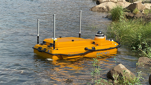
- APACHE3Pro & APACHE4 Pro USVs — Autonomous hydrographic survey vessels for bathymetric mapping
- D390 Echo Sounder — Single-beam bathymetry with GNSS integration and USV compatibility
- CoPre & CoProcess Software — Photogrammetry, LiDAR processing, and 3D modeling from raw data to deliverable
- LandStar 8 Field Software — Android RTK & total station field survey software, three license tiers
- X500 Accessories — B10 batteries, BS10 charging station, EC10 remote controller, propellers & carrying case