


The load carried by an aircraft consisting of things necessary to the purpose of the flight.
113 products

The GeoCue TrueView 720 is the flagship of the TrueView platform family — GeoCue's highest-performance airborne LiDAR and imaging system, engineered for enterprise survey programs, government geospatial agencies, and professional...
Learn More about GeoCue TrueView 720 Flagship UAV LiDAR and Imaging System (NDAA-Compliant)

Aerial Optical Gas Imaging. Hydrocarbon Detection. Methane and Propane. X55 Integrated. The AerialOGI Optical Gas Payload. The AerialOGI Optical Gas Payload is a complete aerial Optical Gas Imaging (OGI) system...
Learn More about AerialOGI Optical Gas Imaging Payload | Methane & Hydrocarbon Detection | Arcsky X55 Integrated

3-in-1 Imaging System for Robotic Dog — UV + IR + VISThe UVIRSYS 3-in-1 Imaging System is a professional-grade multi-spectral payload engineered for robotic dog platforms. Combining ultraviolet (UV), infrared...
Learn More about 3-in-1 Imaging System for Robotic Dog UV+IR+VIS (Basic Unit)

See Everything. Miss Nothing.The UVIRSYS 3-in-1 Imaging System delivers simultaneous Ultraviolet (UV), Infrared (IR), and Visible Light (VIS) imaging in a single compact payload — engineered for professionals who demand...
Learn More about 3-in-1 Imaging System for Drone, UV+IR+VIS Compact version for DJI Matrice 400

The GeoCue TrueView 600 Series is an enterprise-grade family of airborne LiDAR and imaging payloads engineered for the most demanding professional survey, mapping, inspection, and geospatial data collection workflows. Spanning...
Learn More about GeoCue TrueView 600 Series Enterprise UAV LiDAR and Imaging System (NDAA-Compliant)

ZH480 Drone Carried Corona Detection Camera for DJI Matrice 300/350/400 The ZH480 pairs UV, visible, and laser sensors in a single stabilized payload, built to spot corona discharge on power...
Learn More about ZH480 Drone Carried Corona Detection Camera for DJI Matrice 300/350/400

100MP Stabilized iXM-100. 35mm, 80mm, or 150mm Lens. Inspection & Mapping. X55 Integrated. The Phase One P3 Payload. The Phase One P3 Payload is a professional-grade aerial inspection and mapping...
Learn More about Phase One P3 Payload | 100MP iXM-100 | Aerial Inspection & Mapping | Arcsky X55 Integrated

The GeoCue TrueView 500 Series is a professional-grade family of airborne LiDAR and imaging payloads engineered for survey, mapping, inspection, and geospatial data collection at scale. Spanning nine configurations across...
Learn More about GeoCue TrueView 500 Series UAV LiDAR and Imaging System

The TrueView 1 NDAA is an NDAA-compliant, cost-effective aerial mapping solution for professional, government and SLED applications. Designed and manufactured at GeoCue's Alabama facility, it pairs the Ouster OS1 Max...
Learn More about GeoCue TrueView 1 NDAA Drone LiDAR and 26MP Mapping Camera
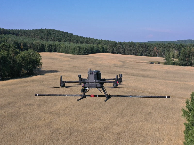
The SENSYS MagDrone R4 is an ultra-lightweight, 5-sensor UAV magnetometer engineered for high-resolution magnetic mapping of small and compact subsurface objects. Featuring five triaxial fluxgate sensors on a rigid sensor...
Learn More about SENSYS MagDrone R4 UAV High-Resolution Magnetometer

Triple-Sensor Gimbal. EO + Thermal + Laser Rangefinder. Dragonfish-Compatible. The Autel Dragonfish L20T Gimbal Camera. The Autel Dragonfish L20T Triple-Sensor Gimbal Camera is a professional multi-sensor aerial payload engineered for...
Learn More about Autel Dragonfish L20T Triple-Sensor Gimbal Camera | Dragonfish Payload

The TrueView 1 NDAA UL delivers high-density LiDAR in a lightweight, NDAA-compliant system. Built around the Ouster OS1 Max Rev8, native direct colorization assigns RGB values to every 3D point...
Learn More about GeoCue TrueView 1 NDAA UL Lightweight Drone LiDAR with Direct Colorization

Summary: The ZH480-mini is a pioneering dual-spectrum imaging payload engineered for small UAVs. Combining a high-resolution UV sensor with a 4K RGB camera, it delivers precise corona discharge detection and...
Learn More about ZH480-mini Corona Detection Imaging System for UAV UV+VIS For M4(T)

CHCNAV C7200 Panoramic Camera — Full-Sphere Aerial Imaging for Professional Mapping and InspectionThe CHCNAV C7200 is a professional-grade 360° panoramic camera payload engineered for UAV-based aerial mapping, infrastructure inspection, and...
Learn More about CHCNAV C7200 Panoramic Camera

* Detects ultraviolet signals in the 240-280nm band, used for partial discharge inspection, not affected by sunlight.* Supports M300RTK and M350RTK, needs to install individual APP.* Basic...
Learn More about CZI UV10
Payloads FAQ
What is drone mapping?
Drone mapping uses a drone with a camera or LiDAR sensor to capture overlapping images or laser points, then software turns them into orthomosaic maps, 3D models and point clouds for surveying, construction and inspection.
Which DJI drone has LiDAR?
DJI puts LiDAR in a payload rather than the aircraft. The DJI Zenmuse L2 is a high-precision aerial LiDAR system that mounts on DJI Matrice enterprise aircraft. The DJI Zenmuse P1 is DJI's full-frame photogrammetry camera for mapping without LiDAR.
How much does a LiDAR drone cost?
The sensor is the main cost. The DJI Zenmuse L2 is listed at $13,999, and the aircraft is priced separately. A Zenmuse L2 rental is also available for short projects.
Where can I fly a drone to map?
Check the FAA's B4UFLY app or UAS Facility Maps for airspace limits before you fly. Commercial mapping in the US needs a Part 107 remote pilot certificate, and controlled airspace needs an FAA authorization.
LiDAR or photogrammetry: which do I need?
LiDAR measures ground under vegetation and works in low light, so it suits corridors, forestry and terrain models. Photogrammetry with a full-frame camera like the Zenmuse P1 gives high-detail color maps of open sites at a lower cost.
What equipment do I need to start drone surveying?
A survey setup is an enterprise aircraft such as a DJI Matrice, a mapping sensor such as the DJI Zenmuse P1 camera or Zenmuse L2 LiDAR, an RTK base station or network for accurate positioning, and processing software. A Part 107 remote pilot certificate is required for commercial work in the US. Current listed prices in this collection: GeoCue TrueView 720 Flagship UAV LiDAR and Imaging System (NDAA-Compliant), $315,000; AerialOGI Optical Gas Imaging Payload, $112,000; 3-in-1 Imaging System for Robotic Dog UV+IR+VIS (Basic Unit), $79,800; 3-in-1 Imaging System for Drone, UV+IR+VIS Compact version for DJI Matrice 400, $79,800; GeoCue TrueView 600 Series Enterprise UAV LiDAR and Imaging System (NDAA-Compliant), $60,000; ZH480 Drone Carried Corona Detection Camera for DJI Matrice 300/350/400, $59,800.
Shop by brand
- DJI
- AUTEL
- Inspired Flight
- Unitree
- Chasing
- QYSEA
- ACSL
- Antigravity
- Arcsky
- CHCNAV
- Agremo
- Deep Robotics
- AGIBOT
- Booster Robotics
- Flybotix
- UVIRSYS
- Corona
- GeoCue
- Elistair
- SPH Engineering
- Vantage Robotics
- AVSS
- BLV